Satellite Image Carnegie, Australia
An ephemeral lake in Western Australia. It fills with water only during periods of significant rainfall. In dry years, it is reduced to a muddy marsh...

Satellite Image Namib Hires Africa
Ancient dunes near Sossusvlei, in the relatively frequently visited center of the national park, accessible by road from Sesriem. The winds that bring in the fog are also responsible for creating...
Satellite Photo Lake Disappointment, Australia
An ephemeral salt lake in a remote area of Western Australia. Lake Disappointment was named by the explorer Frank Hann in 1897. Hann was in the area exploring the east Pilbara, around Rudall River. He noticed creeks in the area flowed inland, and followed them expecting to find a large fresh water lake. To his disappointment the lake turned out to be salt, and subsequently it got its name of Lake Disappointment. The lake is home to many species of waterbirds.

Satellite Photo Coahuila Mexico
Sierra Madre Oriental mountain range, on the border between the Coahuila and Nuevo Leon provinces of Mexico.

Satellite Image Pinacate Park Volcano
Pinacate is a large, roughly 55 x 60 km volcanic field in the Sonoran desert of NW México. It contains numerous youthful maars, tuff rings, and cinder cones of late-Pleistocene to Holocene age. The 2000 sq km volcanic field is prominent in satellite images of this arid, sparsely populated region between the Arizona border and the head of the Gulf of California. An older volcanic episode constructed the 1200-m-high Santa Clara basaltic-to-trachytic shield volcano. This was followed by the eruption of more than 500 basaltic cinder cones and lava flows that blanket the slopes of Santa Clara and the surrounding desert. Among the principal features of the Pinacate volcanic field are Elegante crater, a 1.6-km-wide maar, and Cerro Colorado, a 110-m-high, 1.1-km-wide tuff ring. Papago (Tohono O'odham) Indian legends tell of eruptions, however historical accounts of ash-and-steam eruptions in the 20th century are questionable.

Satellite Image Lake Amadeus, Australia
Like frantic brushstrokes, fire scars cover the arid landscape near the huge salt lake in the area of Uluru (Ayers Rock), located in the southwest corner of Australia's Northern Territory. Due to the aridity of the area, it is usually almost totally dry. In times of sufficient rainfall, it is part of an east-flowing drainage system that eventually connects to the Finke River. Lake Amadeus is 180km long and 10km wide, making it the largest salt lake in the Northern Territory. It contains up to 600 million tonnes of salt, however harvesting it has not proved viable due to its remote location.

Satellite Photo Lena Delta River, Russia
The 10th longest river in the world and has the seventh largest watershed. Rising at the height of 1,640 metres (5,381 ft) at its source in the Baikal Mountains south of the Central Siberian Plateau, 7 kilometres (4 mi) west of Lake Baikal, the Lena flows northeast, being joined by the Kirenga River and the Vitim River. The total length of the river is estimated at 4,400 km (2,800 m.). The area of the Lena river basin is calculated at 2,490,000 square kilometres (961,394 sq mi). Gold is washed out of the sands of the Vitim and the Olyokma, and mammoth tusks have been dug out of the delta. The Lena has the unusual distinction of appearing to be the longest river in the world when viewed on a map using a Mercator projection, the most common method of displaying the spherical earth on a flat surface, due to that projection's tendency to exaggerate the size of areas near the poles (the Amazon and Nile both cross the equator). At the end of the Lena River there is a large delta that is about 400 km (250 miles) wide. The delta is frozen tundra for about 7 months of the year, but in May transforms the region into a lush wetland for the next few months. Part of the area is protected as the Lena Delta Wildlife Reserve. The Lena delta divides into a multitude of flat islands.

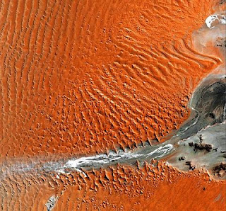
Satellite Image Great Sandy Desert Scars
In a small corner of the vast Great Sandy Desert in Western Australia, large sand dunes --the only sand in this desert of scrub and rock -- appear as lines stretching from left to right. The light-colored fan shapes are scars from wildfires.

Satellite Image Florida Everglades
Everglades National Park is the largest subtropical wilderness in the United States. The area boasts rare and endangered species, such as the American crocodile, Florida panther, and West Indian manatee. It has been designated an International Biosphere Reserve, a World Heritage Site, and a Wetland of International Importance, in recognition of its significance to all the people of the world.

Satellite Image Brandberg Massif Namibia Africa
Over 120 million years ago, a single mass of granite punched through the Earth’s crust and intruded into the heart of the Namib Desert in what is now northern Namibia. Today the mountain of rock called the Brandberg Massif towers over the arid desert below. A ring of dark, steep-sided rocks forced upward during the mountain’s arrival encircles the granite intruder. The locals call it Dâures—the burning mountain. Its volcanism has long since stilled, but the granite core left behind apparently glows red in the light of the setting sun. The formation is a remnant of a long period of tumultuous volcanic and geologic activity on Earth during which the southern super-continent of Gondwana was splitting apart. The mountain influences the local climate, drawing more rain to its flanks than the desert below receives. The rain filters into the mountain’s deep crevices and slowly seeps out through springs. Unique plant and animal communities thrive in its high-altitude environment, and prehistoric cave paintings decorate walls hidden in the steep cliffs that gouge the mountain. To the southwest of Brandberg Massif, an older and more-eroded granite intrusion blends in subtly with the desert landscape, while along the Ugab River at upper left, cracks line the brown face of an ancient plain of rock transformed into gneiss by heat, pressure, and time.

An ephemeral lake in Western Australia. It fills with water only during periods of significant rainfall. In dry years, it is reduced to a muddy marsh...

Satellite Image Namib Hires Africa
Ancient dunes near Sossusvlei, in the relatively frequently visited center of the national park, accessible by road from Sesriem. The winds that bring in the fog are also responsible for creating...

Satellite Photo Lake Disappointment, Australia
An ephemeral salt lake in a remote area of Western Australia. Lake Disappointment was named by the explorer Frank Hann in 1897. Hann was in the area exploring the east Pilbara, around Rudall River. He noticed creeks in the area flowed inland, and followed them expecting to find a large fresh water lake. To his disappointment the lake turned out to be salt, and subsequently it got its name of Lake Disappointment. The lake is home to many species of waterbirds.

Satellite Photo Coahuila Mexico
Sierra Madre Oriental mountain range, on the border between the Coahuila and Nuevo Leon provinces of Mexico.

Satellite Image Pinacate Park Volcano
Pinacate is a large, roughly 55 x 60 km volcanic field in the Sonoran desert of NW México. It contains numerous youthful maars, tuff rings, and cinder cones of late-Pleistocene to Holocene age. The 2000 sq km volcanic field is prominent in satellite images of this arid, sparsely populated region between the Arizona border and the head of the Gulf of California. An older volcanic episode constructed the 1200-m-high Santa Clara basaltic-to-trachytic shield volcano. This was followed by the eruption of more than 500 basaltic cinder cones and lava flows that blanket the slopes of Santa Clara and the surrounding desert. Among the principal features of the Pinacate volcanic field are Elegante crater, a 1.6-km-wide maar, and Cerro Colorado, a 110-m-high, 1.1-km-wide tuff ring. Papago (Tohono O'odham) Indian legends tell of eruptions, however historical accounts of ash-and-steam eruptions in the 20th century are questionable.

Satellite Image Lake Amadeus, Australia
Like frantic brushstrokes, fire scars cover the arid landscape near the huge salt lake in the area of Uluru (Ayers Rock), located in the southwest corner of Australia's Northern Territory. Due to the aridity of the area, it is usually almost totally dry. In times of sufficient rainfall, it is part of an east-flowing drainage system that eventually connects to the Finke River. Lake Amadeus is 180km long and 10km wide, making it the largest salt lake in the Northern Territory. It contains up to 600 million tonnes of salt, however harvesting it has not proved viable due to its remote location.

Satellite Photo Lena Delta River, Russia
The 10th longest river in the world and has the seventh largest watershed. Rising at the height of 1,640 metres (5,381 ft) at its source in the Baikal Mountains south of the Central Siberian Plateau, 7 kilometres (4 mi) west of Lake Baikal, the Lena flows northeast, being joined by the Kirenga River and the Vitim River. The total length of the river is estimated at 4,400 km (2,800 m.). The area of the Lena river basin is calculated at 2,490,000 square kilometres (961,394 sq mi). Gold is washed out of the sands of the Vitim and the Olyokma, and mammoth tusks have been dug out of the delta. The Lena has the unusual distinction of appearing to be the longest river in the world when viewed on a map using a Mercator projection, the most common method of displaying the spherical earth on a flat surface, due to that projection's tendency to exaggerate the size of areas near the poles (the Amazon and Nile both cross the equator). At the end of the Lena River there is a large delta that is about 400 km (250 miles) wide. The delta is frozen tundra for about 7 months of the year, but in May transforms the region into a lush wetland for the next few months. Part of the area is protected as the Lena Delta Wildlife Reserve. The Lena delta divides into a multitude of flat islands.

Satellite Image Great Sandy Desert Scars
In a small corner of the vast Great Sandy Desert in Western Australia, large sand dunes --the only sand in this desert of scrub and rock -- appear as lines stretching from left to right. The light-colored fan shapes are scars from wildfires.

Satellite Image Florida Everglades
Everglades National Park is the largest subtropical wilderness in the United States. The area boasts rare and endangered species, such as the American crocodile, Florida panther, and West Indian manatee. It has been designated an International Biosphere Reserve, a World Heritage Site, and a Wetland of International Importance, in recognition of its significance to all the people of the world.

Satellite Image Brandberg Massif Namibia Africa
Over 120 million years ago, a single mass of granite punched through the Earth’s crust and intruded into the heart of the Namib Desert in what is now northern Namibia. Today the mountain of rock called the Brandberg Massif towers over the arid desert below. A ring of dark, steep-sided rocks forced upward during the mountain’s arrival encircles the granite intruder. The locals call it Dâures—the burning mountain. Its volcanism has long since stilled, but the granite core left behind apparently glows red in the light of the setting sun. The formation is a remnant of a long period of tumultuous volcanic and geologic activity on Earth during which the southern super-continent of Gondwana was splitting apart. The mountain influences the local climate, drawing more rain to its flanks than the desert below receives. The rain filters into the mountain’s deep crevices and slowly seeps out through springs. Unique plant and animal communities thrive in its high-altitude environment, and prehistoric cave paintings decorate walls hidden in the steep cliffs that gouge the mountain. To the southwest of Brandberg Massif, an older and more-eroded granite intrusion blends in subtly with the desert landscape, while along the Ugab River at upper left, cracks line the brown face of an ancient plain of rock transformed into gneiss by heat, pressure, and time.


0 comments:
Post a Comment